Essential information for preparing your hike
| Difficulty | Easy | |
| Distance | 175.7 KM | |
| Height / altitude | 850 meters | |
| Elevation gain | 400 meters | |
| Dog allowed |
Trail maps

Trails available at Mont du Dôme
List of suggested loops and routes
| Trails | Distance | Elevation | Type | Difficulty |
|---|---|---|---|---|
Sentier du Raccourci |
0.8 km | 0 m | Linear | Beginner |
Sentier Eudore Fortin |
9.2 km | 0 m | Loop | Intermediate |
Sentier du Mont du Dôme |
7.8 km | 0 m | Mixt | Intermediate |
Sentier du Button |
3.1 km | 0 m | Linear | Intermediate |
Sentier du Cadot |
2.6 km | 0 m | Linear | Intermediate |
Sentier du Lac à la Main |
2.2 km | 0 m | Linear | Intermediate |
Mont du Lac à l'Empêche et mont du Four |
14 km | 250 m | Loop | Intermediate |
Boucle des Sommets |
11.6 km | 0 m | Loop | Intermediate |
La Traversée de Charlevoix (SNQ*) - Sentier national |
105 km | 400 m | Linear | Advanced |
Sentier du Bihoreau |
10 km | 0 m | Loop | Advanced |
Sentier de la Noyée |
10 km | 0 m | Linear | Advanced |
↔️ Glissez pour voir tous les détails
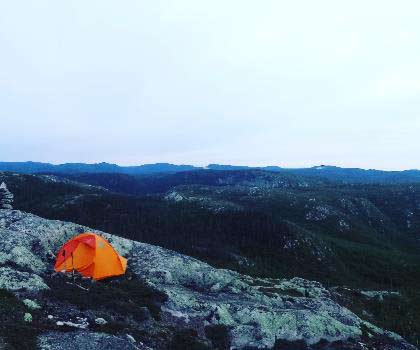
Photos
Discover Mont du Dôme: A Hiker's Paradise in Charlevoix
Welcome to mont du dôme, a hidden gem nestled in the breathtaking region of Charlevoix, Quebec. If you're a hiker, outdoor enthusiast, or simply someone who loves spending time in nature, this is the perfect destination for your next adventure.
Why Mont du Dôme?
mont du dôme offers an unforgettable hiking experience with its diverse trails and stunning vistas. Whether you're a seasoned hiker or just starting out, you'll find a trail that suits your pace and skill level. The mountain stands proudly at an elevation of approximately 800 meters, providing panoramic views that are nothing short of spectacular.
Trail Highlights
The trails at mont du dôme wind through lush forests and open meadows, offering hikers a chance to immerse themselves in the natural beauty of Charlevoix. As you ascend, keep an eye out for local wildlife such as deer and various bird species that call this area home. The summit rewards you with sweeping views of the surrounding landscape, including the majestic St. Lawrence River and rolling hills that stretch as far as the eye can see.
Plan Your Visit
Before heading out, make sure to check the weather conditions and pack accordingly. Sturdy hiking boots, plenty of water, and a camera to capture the stunning scenery are must-haves for your trip. The trails are well-marked and maintained, making it easy to navigate even if it's your first visit.
Getting There
mont du dôme is conveniently located within driving distance from major cities like Quebec City and Montreal. Ample parking is available at the trailhead, ensuring a hassle-free start to your adventure.
A Friendly Reminder
While exploring mont du dôme, please remember to respect the natural environment by staying on designated trails and carrying out any trash you bring in. Let's work together to preserve this beautiful area for future generations of hikers and nature lovers.
So lace up your hiking boots and get ready to explore one of Charlevoix's most captivating landscapes. mont du dôme awaits with open arms and endless opportunities for adventure!
Services and activities on site
Useful infos
Rate & open hour
47.6683493
Address
Starting Point
You must follow route 138 east from Baie-Saint-Paul and then route 381 north to the welcome station, at kilometer 10.6. A white house is located on the right, behind the old museum.
The trailhead is at kilometer 23.2 of route 381, north of the village of Saint-Urbain, the Dome parking lot is 2 km north of Mont-du-Lac-des-Cygnes.
FAQ - Frequently asked questions
What is the level of difficulty of Mont du Dôme ?
What is the elevation of Mont du Dôme?
What is the height of Mont du Dôme ?
Are dogs allowed?
Is the place are families friendly?
Is there an information center / service center / reception?
Similar hikes nearby


She life was a celebration of adventure, joy, and the great outdoors. She lived with a fierce determination to enjoy every moment and to share that joy with others. Her legacy is one of laughter, exploration, and an unwavering love for the natural world. Lydia's spirit continues to inspire those who knew her and those who discover her story, reminding us all to embrace life with open arms and a heart full of joy.
Hikers' opinions
4 out of 5 stars
Based on 5 reviews