
 By
By
| Elevation gain | 577 meters |
See photos of hiking
Why choose a trail at Mont Comi?
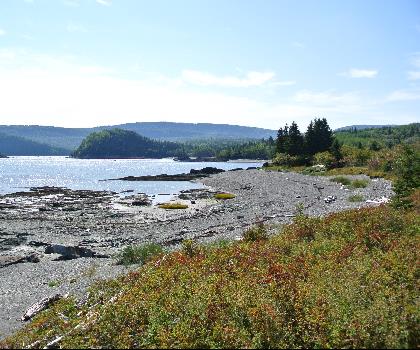
Welcome to mont comi, a hiker's paradise nestled in the heart of the Bas-Saint-Laurent region! If you're an outdoor enthusiast or someone looking to immerse yourself in nature, mont comi is the perfect destination for your next adventure.
mont comi stands proudly as one of the most popular hiking spots in the area, offering breathtaking views and a variety of trails suitable for all skill levels. Whether you're a seasoned hiker or just starting out, you'll find a path that suits your pace and preference. The mountain's diverse terrain promises an exciting journey through lush forests, open meadows, and rocky outcrops.
One of the highlights of mont comi is its summit, which rewards hikers with panoramic vistas of the surrounding landscape. On a clear day, you can see for miles across the picturesque Bas-Saint-Laurent region, making it an ideal spot for photography enthusiasts and nature lovers alike. Don't forget to bring your camera!
For those who enjoy more than just hiking, mont comi offers additional outdoor activities throughout the year. In winter, it transforms into a bustling ski resort with slopes catering to both beginners and experienced skiers. During warmer months, it's a haven for mountain biking and wildlife observation.
The friendly atmosphere at mont comi extends beyond its trails. You'll find welcoming locals and fellow adventurers eager to share tips and stories about their experiences. Plus, there are plenty of amenities nearby, including cozy accommodations and delightful eateries where you can refuel after a day of exploration.
So lace up your hiking boots and get ready to discover the natural beauty of mont comi. Whether you're seeking solitude in nature or an exhilarating outdoor challenge, this gem in Bas-Saint-Laurent has something special waiting for you. Happy hiking!
Trail maps

Rate & open hour
48.4669444
What are the coordinates and address ?
Starting Point
To access the hiking trails, head towards the main parking lot located at 120 Chemin du Mont-Comi, Saint-Donat-de-Rimouski, Quebec. This is the primary starting point for most of the trails in the area.
Why visit Mont Comi
Mount Comi is located about an hour's drive from Rimouski and Riviere-du-Loup. It is easily accessible and offers a breathtaking view of the region. There are also many hiking trails, making it an ideal place for outdoor enthusiasts.
Things not to be missed
Mount Comi is located near the town of Riviere-du-Loup, in the Lower St. Lawrence region. This region is known for its beautiful landscapes and preserved nature. Near Mount Comi, you can visit the Gaspesie National Park, which is one of the most beautiful parks in Canada. This park is famous for its mountains and glaciers, as well as for its exceptional flora and fauna. Just a few minutes away from Mount Comi is the fishing village of La Pocatière, which is a popular destination for tourists. This village is famous for its fishing port and gourmet restaurants.
The mont comi campground is located in Saint-André-de-Kamouraska, in the Lower St. Lawrence. It offers a breathtaking view of the St. Lawrence River and the surrounding mountains.
Let’s Answer Your Questions - FAQ
-
No
-
No
What is the elevation of Mont Comi?
Is the place are families friendly?
Is there an information center / service center / reception?
Explore other trails in Bas-Saint-Laurent


She life was a celebration of adventure, joy, and the great outdoors. She lived with a fierce determination to enjoy every moment and to share that joy with others. Her legacy is one of laughter, exploration, and an unwavering love for the natural world. Lydia's spirit continues to inspire those who knew her and those who discover her story, reminding us all to embrace life with open arms and a heart full of joy.
Hiker reviews on this trail
5 out of 5 stars
Based on 1 reviews
Recent reviews