Essential information for preparing your hike
| Difficulty | Easy | |
| Distance | 14.7 KM | |
| Elevation gain | 300 meters |
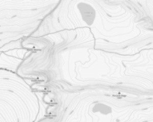
Trail maps

Trails available at Parc National De L'île-bonaventure-et-du-rocher-percé
List of suggested loops and routes
| Trails | Distance | Elevation | Type | Difficulty |
|---|---|---|---|---|
Boucle secteur île-Bonaventure |
8.2 km | 300 m | Loop | Intermediate |
Sentier Chemin-du-Roy |
4.7 km | 75 m | Linear | Intermediate |
Sentier Paget |
3.7 km | 90 m | Linear | Intermediate |
Sentier des Mousses |
3.5 km | 120 m | Linear | Intermediate |
Sentier des Colonies |
2.8 km | 135 m | Linear | Intermediate |
↔️ Glissez pour voir tous les détails
Photos
Welcome to the breathtaking Parc National De L'île-Bonaventure-et-du-Rocher-Percé, a true gem nestled in the heart of the Gaspésie - Îles-de-la-Madeleine region. If you're a hiker, outdoor enthusiast, or simply someone who cherishes spending time in nature, this park is your perfect destination.
Imagine stepping into a world where rugged cliffs meet the vast expanse of the sea, and lush greenery surrounds you at every turn. This park is renowned for its stunning landscapes and diverse ecosystems, offering an unforgettable experience for all who visit.
One of the highlights of Parc National De L'île-Bonaventure-et-du-Rocher-Percé is its extensive network of hiking trails. Whether you're a seasoned hiker or just starting out, there's a trail for everyone. The trails range from easy walks that allow you to soak in the serene beauty of the surroundings to more challenging hikes that reward you with panoramic views of the Gulf of St. Lawrence.
As you explore, keep an eye out for the park's rich wildlife. It's home to one of the largest colonies of Northern Gannets in North America. Watching these magnificent birds soar above the cliffs is a sight you won't want to miss.
The iconic Rocher Percé, a massive rock formation rising dramatically from the sea, is another must-see attraction within the park. Its unique shape and size make it one of Canada's most photographed landmarks.
For those interested in history and culture, the island offers insights into its past with well-preserved heritage buildings and informative exhibits about its former fishing community.
Whether you're here for a day trip or planning to camp under the stars, Parc National De L'île-Bonaventure-et-du-Rocher-Percé promises an adventure filled with natural beauty and tranquility. So lace up your hiking boots, grab your camera, and get ready to create memories that will last a lifetime in this spectacular corner of Quebec!
Services and activities on site
Useful infos
Rate & open hour
Tuesday: 9:00 AM – 5:00 PM
Wednesday: 9:00 AM – 5:00 PM
Thursday: 9:00 AM – 5:00 PM
Friday: 9:00 AM – 5:00 PM
Saturday: 9:00 AM – 5:00 PM
Sunday: 9:00 AM – 5:00 PM
48.522277
Address
Starting Point
To access the hiking trails, head to the main entrance located at 4 Rue du Quai, Percé, QC G0C 2L0. From there, you can take a ferry to reach the island where the trails begin. There are no alternative trailheads on the island itself; all visitors must start from this point.
FAQ - Frequently asked questions
What is the level of difficulty of Parc National De L'île-bonaventure-et-du-rocher-percé ?
What is the elevation of Parc National De L'île-bonaventure-et-du-rocher-percé?
What are the opening hours?
Tuesday: 9:00 AM – 5:00 PM
Wednesday: 9:00 AM – 5:00 PM
Thursday: 9:00 AM – 5:00 PM
Friday: 9:00 AM – 5:00 PM
Saturday: 9:00 AM – 5:00 PM
Sunday: 9:00 AM – 5:00 PM
Is the place are families friendly?
How much does a ticket cost?
Is there an information center / service center / reception?
Similar hikes nearby


She life was a celebration of adventure, joy, and the great outdoors. She lived with a fierce determination to enjoy every moment and to share that joy with others. Her legacy is one of laughter, exploration, and an unwavering love for the natural world. Lydia's spirit continues to inspire those who knew her and those who discover her story, reminding us all to embrace life with open arms and a heart full of joy.
Hikers' opinions
5 out of 5 stars
Based on 5 reviews