Essential information for preparing your hike
| Difficulty | Easy | |
| Distance | 27.9 KM | |
| Elevation gain | 100 meters | |
| Dog allowed |
Trail maps

Trails available at Parc national d'Aiguebelle
List of suggested loops and routes
| Trails | Distance | Elevation | Type | Difficulty |
|---|---|---|---|---|
Le Petit-Nomade |
2.2 km | Loop | Beginner | |
La Castorière |
0.8 km | Loop | Beginner | |
La salamandre |
4 km | 40 m | Linear | Intermediate |
La Traverse |
3 km | 70 m | Loop | Intermediate |
Les Garde-Feu |
2 km | 100 m | Linear | Intermediate |
Les Paysages |
2 km | 100 m | Loop | Intermediate |
L'Élan |
1.5 km | 100 m | Loop | Intermediate |
L'Aventurier |
9.5 km | 70 m | Loop | Advanced |
L'Escalade |
2.5 km | 100 m | Linear | Advanced |
Les Versants |
11 km | 70 m | Linear | Advanced |
↔️ Glissez pour voir tous les détails
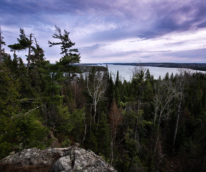
Photos
The Aiguebelle National Park canbe summed up in two words: history and adventure. With its 2.7 billion-year-old geologicalconfomation and fault lakes, this park retains a great natural heritage that is the pride of the Abitibi-Témicasmingueregion.
The park is located in Rouyn-Noranda, just in the middle of the region and on the watershed between Hudson Bay and the ancient Atl Ocean. The southern part of itsrritoire is occupied by the volcanic hills Abijévis.
In addition, in the Aiguebelle National Park we have the opportunity to test yourself with more than 50km of short or long hiketrails, which have all the appearance ofa real adventurouspath. Get off vertiginous escarpments, pass by a suspension bridge and climb on ahelicalscalier... it'll be like in a movie!
Here you can observe the ancientaniseed robbing rocks, the traces of the passage of glaciers and the co-eas of lava, walking or leaving temptedby acrossed by sea kayak. If youdon't have all the necessary equipment,don't panic: the park will allow you to rent everything you need!
A recommended trail
The hikingtrails of the park areeasy (the famous La Castorière trail, for example) to thehighland. Some also offer the possibility of spending the night in a rustic log camp toenjoythe adventure.
A recommended path of intermealdifficultyis that of the Ḗscalade. It is a line (round trip) of about 1.56km, with a vertical drop of 160m. During this hike you can:
· Climb to the top of La Deceit Hill
· Admire the fall of La Haie Creek, with its clear waters
· Enjoy a magnificent view of the hills
· Spend an evening out of theordinary at the rustic camp La Cigale
The trail is not very difficult, but it is still better to equip yourself with a good pair of shoes, since there are some steep slopes.
To conclude, here are some practical information: the starting point of the Ḗscalade trail is located in the parking lot of Lac La Haie,which can easily be reached by car,following Route 26.
Aiguebelle National Park is a national park in Quebec. It is located partly in Mont-Brun and Taschereau, in the Abitibi-Témiscamingue tourist region and about 50 kilometres from Rouyn-Noranda. It covers an area of 268.3 km2. The park was established in 1985 and underwent a boundary review in 1998. Its mission is to protect a representative sample of the Abitibi clay belt and the Abijévis Hills.
A bit of snowshoeing
Only the squealing of your snowshoes digging in the snow and your breath transforming the crystalline air into a fine mist blur the silence of Aiguebelle. At Lac La Haie or on the top of La Trompeuse Hill, every step you take leaves your mark on the hare, ruffed grouse and moose that cross these amazing landscapes. A total of 40 kilometres, divided into four marked trails, allow you to fully appreciate your human dimension in this northern whiteness. Do you see the pretty rustic shelter in the distance? This could be your base camp for one or more nights. Two hours, two days, two weeks....take all the time you need in the exhilarating winter purity of Aiguebelle National Park.
Our suggestions nearby Chalets du parc national d'Aiguebelle The Aiguebelle National Park, in the heart of Abitibi Témiscamingue, offers you the opportunity to stay in one of its rustic camps at a modest price, in an enchanting setting. In summer, in the Lac Loïs sector, Exotic and accessible Aiguebelle National Park, Aiguebelle National Park is an exceptional place that invites you to calm and contemplation. Observe the traces of the passage of glaciers and rocks worth 2.7 billion La Cité de l'Or Discover the two historic sites that make up the Cité de l'Or de Val-d'Or in Abitibi-Témiscamingue. L'Ancienne-Mine-Lamaque is an interpretation centre. Become a miner for a day and live a unique experience at Refuge Pageau Le Refuge Pageau was created in 1986 by Michel Pageau and his wife Louise. Refuge Pageau welcomes wild animals in need for rehabilitation with a view to releasing them back into the wild. When Opémican National Park Opémican National Park is located on the territory of the MRC de Témiscamingue, in the tourist region of Abitibi-Témiscamingue. Bordered on either side by lakes Témiscamingue and Kipawa, the national park.
Services and activities on site
Useful infos
Rate & open hour
48.4306989
Address
Starting Point
To access the hiking trails, you can start at one of the main entrances. The first trailhead is located at 12373 Route d'Aiguebelle, Rouyn-Noranda, QC J0Z 2Y0. Another possible starting point is at 1000 Chemin du Parc-National, Taschereau, QC J0Z 3N0. Both locations have parking facilities available for visitors.
FAQ - Frequently asked questions
What is the level of difficulty of Parc national d'Aiguebelle ?
What is the elevation of Parc national d'Aiguebelle?
Are dogs allowed?
Is the place are families friendly?
How much does a ticket cost?
Is there an information center / service center / reception?
Similar hikes nearby


She life was a celebration of adventure, joy, and the great outdoors. She lived with a fierce determination to enjoy every moment and to share that joy with others. Her legacy is one of laughter, exploration, and an unwavering love for the natural world. Lydia's spirit continues to inspire those who knew her and those who discover her story, reminding us all to embrace life with open arms and a heart full of joy.
Hikers' opinions
5 out of 5 stars
Based on 5 reviews